")


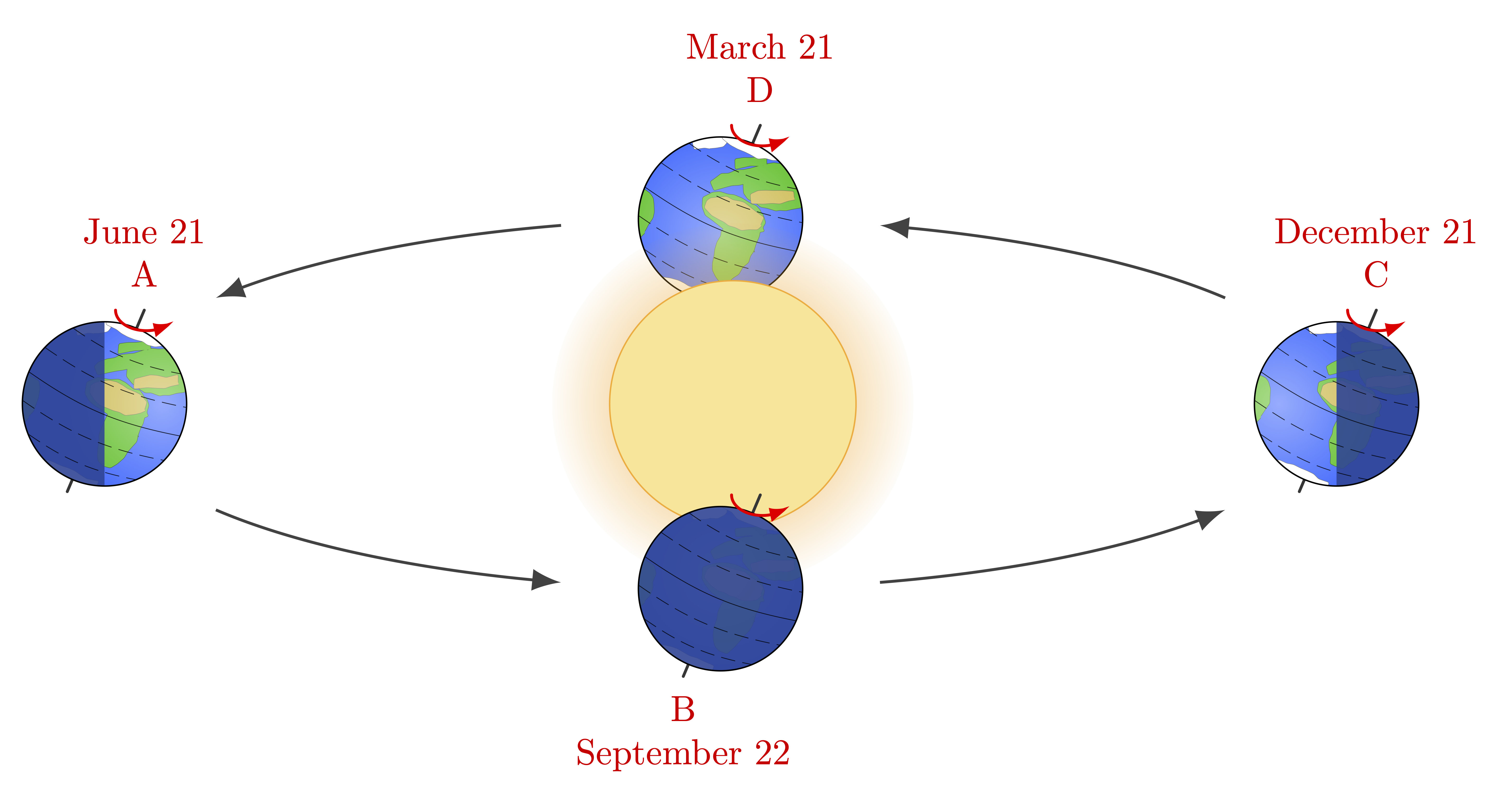
Seasons of Earth due to Earth’s tilted axis of rotation w.r.t. its orbital plane.
Main idea
One can use pic to predefine a picture of Earth:
\documentclass[border=3pt,tikz]{standalone}
\tikzset{
  pics/earth/.style={ % Earth in orbit (argument #1 = polar angle)
    code={
      \message{^^JEarth polar angle=#1}
      \draw[black,very thin,fill=blue!50!cyan!50]
         (#1:{\ROx} and {\ROy}) circle(\RE);
    }
  }
}
\begin{document}
\begin{tikzpicture}
  \def\RE{0.4} % Earth radius
  \def\ROx{3.0} % orbit horizontal radius
  \def\ROy{0.9} % orbit vertical radius
  \foreach \ang in {0,90,180,270}{
    \pic {earth=\ang};
  }
\end{tikzpicture}
\end{document}
Using \ifnum .. \fi, one can define special cases:
\documentclass[border=3pt,tikz]{standalone}
\tikzset{
  pics/earth/.style={ % Earth in orbit (argument #1 = polar angle)
    code={
      \message{^^JEarth polar angle=#1}
      \coordinate (-O) at (#1:{\ROx} and {\ROy});
      \begin{scope}[shift={(-O)}]
        \fill[blue!50!cyan!50] (0,0) circle(\RE); % Earth fill (even)
        \fill[blue!20!black!50,rotate=0,opacity=0.9] % Earth shadow
          \ifnum #1=0 (90:\RE) arc(90:-90:\RE) \fi % right shadow
          \ifnum #1=180 (90:\RE) arc(90:270:\RE) \fi % left shadow
          \ifnum #1=270 (0,0) circle(\RE) \fi; % full shadow
        \draw[black,very thin] (0,0) circle(\RE); % Earth outline
      \end{scope}
    }
  }
}
\begin{document}
\begin{tikzpicture}
  \def\angE{23} % Earth axis tilt
  \def\RE{0.4} % Earth radius
  \def\ROx{3.0} % orbit horizontal radius
  \def\ROy{0.9} % orbit vertical radius
  \foreach \ang in {0,90,180,270}{
    \pic {earth=\ang};
  }
\end{tikzpicture}
\end{document}
To create a transparent halo, we use fading:
\documentclass[border=3pt,tikz]{standalone}
\usetikzlibrary{fadings}
\begin{tikzfadingfrompicture}[name=halo]
  \shade[inner color=transparent!0,outer color=transparent!100] (0,0) circle (0.9);
\end{tikzfadingfrompicture}
\begin{document}
\begin{tikzpicture}
  \fill[blue!60!black] (-5,-5) rectangle (5,5);
  \fill[path fading=halo,orange!80!yellow!80] % solar halo/corona
    (0,0) circle (5);
  \draw[very thin,orange!80!yellow!80,fill=orange!50!yellow!40] % Sun
    (0,0) circle (2);
\end{tikzpicture}
\end{document}
Full code
Edit and compile if you like:
% Author: Izaak Neutelings (January 2024)
\documentclass[border=3pt,tikz]{standalone}
\usetikzlibrary{arrows.meta,bending} % for arrow head size
\usetikzlibrary{calc} % for calculating coordinates
\usetikzlibrary{decorations.pathmorphing} % for random steps
\usetikzlibrary{fpu} % for higher precision in "random steps"

% FADINGS
\usetikzlibrary{fadings}
\begin{tikzfadingfrompicture}[name=halo]
  \shade[inner color=transparent!0,outer color=transparent!100] (0,0) circle (0.9);
\end{tikzfadingfrompicture}
%\begin{tikzfadingfrompicture}[name=bright spot]
%  \shade[inner color=transparent!50,outer color=transparent!100] (0,0) circle (0.6);
%\end{tikzfadingfrompicture}

% COLORS
\usepackage{xcolor}
\colorlet{water}{blue!70!cyan!80}
\colorlet{grass}{green!70!teal!90!black}
\colorlet{sand}{yellow!70!brown!90!black}
\colorlet{shadow}{water!60!black}

% STYLES & MACROS
\def\angE{23} % Earth axis tilt
\def\RE{0.4} % Earth radius
\def\ROx{3.0} % orbit horizontal radius
\def\ROy{0.9} % orbit vertical radius
\def\drawmap{ % map of earth
  \fill[land=grass,rotate=-2] % land mass
    (-30:0.36*\RE) ellipse({0.22*\RE} and {0.50*\RE}) % Africa south
    (45:0.17*\RE) ellipse({0.39*\RE} and {0.21*\RE}) % North Africa
    {[rotate=22] (31:0.83*\RE) ellipse({0.45*\RE} and {0.28*\RE})} % Asia
    {[rotate=38] (54:0.55*\RE) ellipse({0.33*\RE} and {0.09*\RE})} % West Europa
    {[rotate=22] (65:0.79*\RE) ellipse({0.19*\RE} and {0.04*\RE})} % North Europa
    {[rotate=-10] (216:1.10*\RE) ellipse({0.22*\RE} and {0.40*\RE})} % South America
  ;
  \fill[land=sand] % sahara
    (46:0.18*\RE) ellipse({0.35*\RE} and {0.16*\RE});
  \fill[land=sand,rotate=22] % Middle East
    (24:0.69*\RE) ellipse({0.26*\RE} and {0.07*\RE});
  \fill[land=white,rotate=-65] (186:0.95*\RE) ellipse({0.08*\RE} and {0.20*\RE}); % Greenland
  \fill[land=white] (88:\RE) ellipse({0.4*\RE} and {0.13*\RE}); % ice sheet north
  \fill[land=white] (-96:\RE) ellipse({0.4*\RE} and {0.1*\RE}); % ice sheet south
}
\tikzset{
  >=latex, % for LaTeX arrow head
  /pgf/fpu/install only={reciprocal}, % for higher precision in "random steps"
  orbit/.style={-{latex[scale=0.8,bend]},black!75}, %dashed
  altitude/.style={ultra thin,dash pattern=on 2pt off 1pt,opacity=0.8}, %dashed
  note/.style={red!90!black,align=center,scale=0.5},
  wrinkle/.style={rounded corners=0.2pt,decorate,decoration={random steps,segment length=1pt,amplitude=0.2pt}},
  land/.style={ultra thin,draw=#1!40!black,rotate=-\angE,postaction={fill=#1},wrinkle},
  mysmallarrow/.style={-{Latex[length=3,width=2,bend]},red,line width=0.4,line cap=round},
  pics/earth/.style={ % Earth in orbit (argument #1 = polar angle)
    code={
      \message{^^JEarth polar angle=#1}
      \coordinate (-O) at (#1:{\ROx} and {\ROy});
        \begin{scope}[shift={(-O)}]
        \draw[black!80,line cap=round] % tilted axis
          (0,0)++(90-\angE:1.24*\RE) coordinate(-N) % north
          --++ (-90-\angE:2.40*\RE) coordinate (-S); % south
        \fill[water] (0,0) circle(\RE); % Earth fill (even)
        \begin{scope} % clip
          \clip (0,0) circle(\RE);
          \drawmap
          \fill[path fading=halo,white,opacity=0.42] % create bright spot shifted towards sun
            (#1-180:{0.7*\RE} and {0.2*\RE}) circle(1.2*\RE);
        \end{scope}
        \fill[shadow,rotate=0,opacity=0.9] % Earth shadow
          \ifnum #1=0 (90:\RE) arc(90:-90:\RE) \fi % right shadow
          \ifnum #1=180 (90:\RE) arc(90:270:\RE) \fi % left shadow
          \ifnum #1=270 (0,0) circle(\RE) \fi; % full shadow
        \draw[rotate=-\angE,altitude,solid] % equator
          (-\RE,0) to[out=-12,in=-168] (\RE,0);
        \foreach \i [evaluate={\y=0.35*\i*\RE;\x=sqrt(\RE*\RE-\y*\y);}] in {1,2}{
          \draw[rotate=-\angE,altitude] % altitude lines
            (-\x,\y) to[out=-12,in=-168] (\x,\y)
            (-\x,-\y) to[out=-12,in=-168] (\x,-\y);
        }
        \draw[black,very thin] (0,0) circle(\RE); % Earth outline
        \draw[mysmallarrow] % indicate rotation
          (90-\angE:1.24*\RE)++(180:{0.14} and {0.1}) arc(180:330:{0.15} and {0.1});
      \end{scope}
    }
  }
}

\begin{document}

% EARTH in orbit
\begin{tikzpicture}
  \coordinate (O) at (0,0);
  \coordinate (S) at (0.02*\ROx,0); % sun (slightly shifted to focus, eccentricity ~ 0.02)

  % SUN
  \pic (E90) at (O) {earth=90}; % draw Earth behind sun (March)
  \fill[path fading=halo,orange!80!yellow!80] % solar halo/corona
    (S) circle (2.2*\RE);
  \draw[very thin,orange!80!yellow!80,fill=orange!50!yellow!40] % Sun
    (S) circle (1.5*\RE);

  % EARTHS
  \foreach \ang in {0,180,270}{
    \pic (E\ang) at (O) {earth=\ang}; % draw in front of sun
  }
  \node[note,above=3pt] at (E180-N) {June 21\\A};
  \node[note,below=2pt] at (E270-S) {B\\September 22};
  \node[note,above=3pt] at (E0-N) {December 21\\C};
  \node[note,above=3pt] at (E90-N) {March 21\\D};

  % LABELS
  \foreach \i [evaluate={\anga=(\i-1)*90+(mod(\i,2)==0?15:35)}] in {1,...,4}{
    \draw[orbit] % orbit
      (\anga:{\ROx} and {\ROy}) arc(\anga:\anga+40:{\ROx} and {\ROy});
  }

\end{tikzpicture}

\end{document}
Click to download: astronomy_earth.tex • astronomy_earth.pdf
Open in Overleaf: astronomy_earth.tex


Very nice art, but it seems like there is a mistake. In the solstices, the shadow should be vertical, not tilted with earth’s axis.
Hi Tal,
Thank you for the correction! It’s fixed now…
Cheers,
Izaak